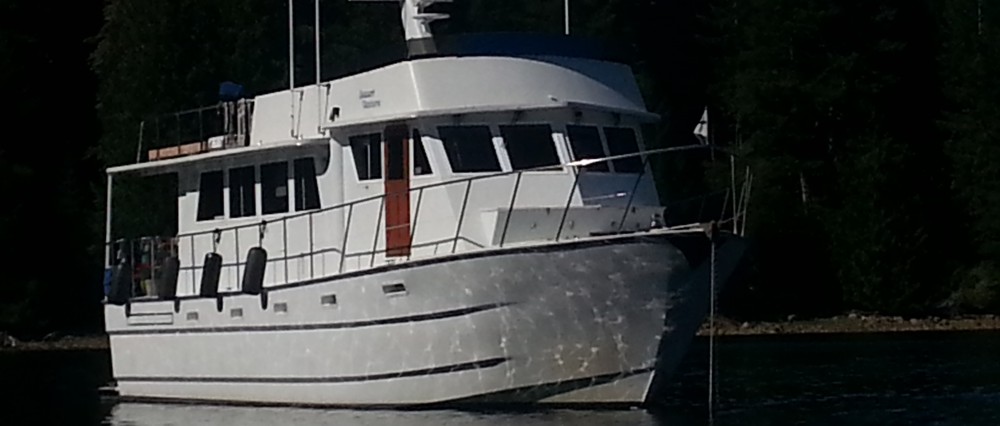
M/V DESERT VENTURE
Why We Go – Because We Can!
June 29, 2008
It is hard to believe that it has been a month and a half since I posted to our blog. I have several very valid excuses – really, we weren’t having too much fun! J Well, the truth is we have been having a great time and there seems little time to sit around a computer and compose. Also, the internet connections have not been amiable to posting to blogs. Those are the best excuses I could come up with quickly.
We have moved an average of every two to three days. We are traveling an average of 13 miles each time we move. There were a few longer voyages, two of 34 miles (round trip to BC mainland) and the last was 70 miles. I wasn’t thrilled with the 70 mile day as I had been lured into thinking it was going to be a thirty-something day, stopping at Tribune Bay – a new place for us, then on to Campbell River a couple days later. Well, anyone that knows us knows that the Captain never passes up a “free ride” up a major body of water. The Strait of Georgia is known for its winds and so if you get a no wind-no sea day to traverse the 70 miles you take it – and we did.
Well, that was just a couple weeks ago! We spent most of June cruising in the Southen Gulf Islands. We spent ten days with friends on DISCOVERY hopping to all our favorite spots, and them getting to see the places for the first time. We cruised from Ganges on Salt Spring Island (where we met up) to Montague Harbour, Thetis Harbor, Nanimo, Pender Harbor (mainland BC), Egmont Marina, and then up Jervis Inlet to Chatterbox Falls. On our return to Pender Harbor, from the falls, we went our separate ways, them to head back to the states and us back to Nanaimo, where we would be picking up the Captain’s parents for a week of slow cruising.
Jervis Inlet and Chatterbox Falls was a first for us. The trip is about 35 miles up several inlets that end at Princess Louisa Inlet, with the Malibu Rapids at the mouth of the inlet. The entire trip is timed based on the timing at Malibu Rapids. The rapids flow at a rate of anywhere from slack to nine knots. The entrance is an “S” curve and the only sensible time to enter or depart is at slack water, as there are very strong eddies and whirlpools at both ends of the rapids. It is a narrow entrance and one boat passes at a time, for the safest transit. We arrived a half hour early and waited with a couple other boats until slack. The other boats decided that we should go first, which was no problem for us, and they all made successful passage, too.
Chatterbox Falls is at the very end of Princess Louisa Inlet. This is a protected marine park, that is only accessible via water. There is a dock, but no other facilities. The dock is a real convenience as it is very deep and there are few safe places to anchor. The dock is limited to boats of 55’, so the bigger yachts must anchor. It rained on us most of the day we voyaged to the falls. The rain was not a problem for us, and it made Chatterbox Falls quite spectacular, having been fed not only from the upper streams but the heavy rain of the day.
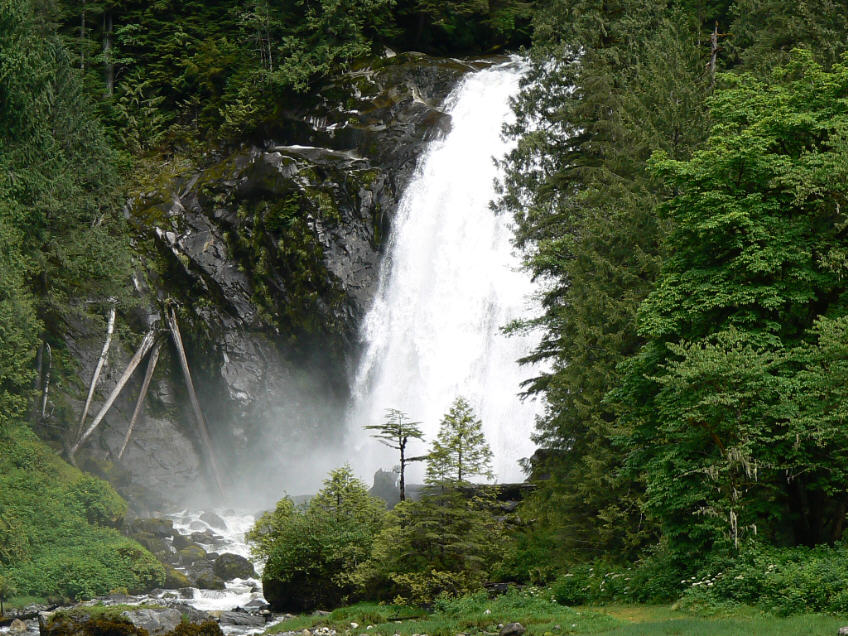
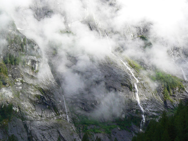
The scenery on the way up the inlets was spectacular. Very steep to and tree covered mountain sides with dozens of waterfalls cascading into the inlets.
Once again the vistas are so grand that it is hard for photos to do justice. I took well over a hundred pictures the day of our voyage. It is impossible to not feel quite small and insignificant in the company of this beautiful place on earth.
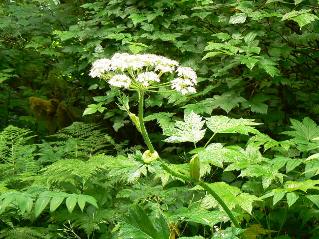 Our travels, thus far this season, have led us progressively north and thus following spring as it travels north, too. The trees, shrubs, and flowers have been in the first budding stages throughout our travels. The trees look velvet with their bright green new buds. One wants to pet them, they are so fresh and inviting. However, one must be careful which plant they “pet”. I was quite taken with this flowering plant. If you look close it has a wonderful velvety pod where another shoot is about to be revealed. I couldn’t resist just “barely” touching the yellow “pod” half way down the stem. The plant “exploded” with bugs that swarmed me! I had not seen them lurking all over the flower. Whew! What an unexpected surprise. Indeed, I had what appeared to be bites down the side of my leg, and encountered large welts on my wrists until finally all the clothing I had been wearing had been relegated to the laundry. I also seemed to have a major allergy reaction that took several weeks to finally overcome. If I read my plant guide book correctly, the plant is called Cow – Parsnip. It seems the Giant Cow – Parsnip can be highly poisonous, too. Either has potential poisonous issues. What a surprise that was! Well, I have fully recovered and intend to be more cautious about plants in the future.
 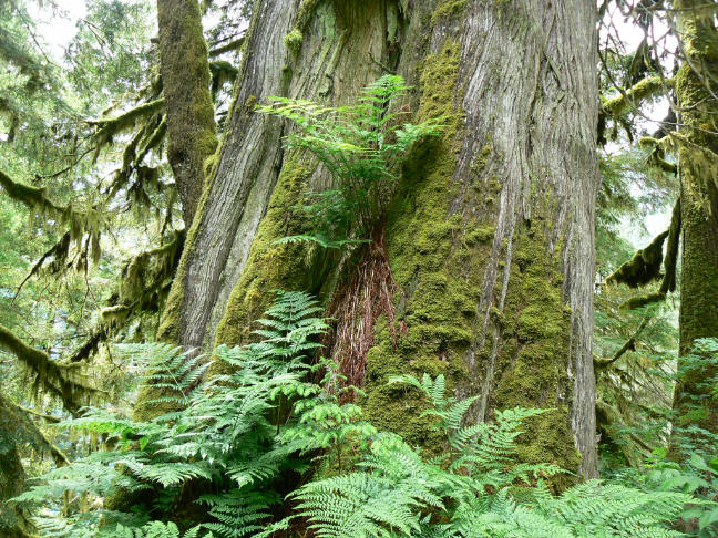 This picture is another taken at Chatterbox Falls. The foliage here certainly exhibits the pioneer spirit of clinging to whatever it can find to take root, grow, and thrive. Beautiful! It is hard for me to not be emotionally moved by the very basic level of existence in the forest.
There are many guide books for boaters and other travelers of British Columbia. They will tell you all about the places we have been, giving you highlights of all the places we have been, the places we have dined, and many more than the sights we have seen. I found myself almost writing another cruising guide but changed gears as I feel you would rather read about special places and moments. If you want specific details please let me know.
We have been experiencing some beautiful sunsets this spring. We probably take a dozen pictures of the same sunset. The sunset starts out nice, then a bit more, and then more, until the first pictures pale at the ultimate peak of the sunset. This first picture below was taken at Pender Harbor on the BC Mainland looking out at Malaspina Strait. The second picture was taken at Silva Bay, Gabriola Island, looking out toward the Strait of Georgia.

 We have been mixing up our time between being at the dock and anchoring. Going to a dock generally means provisioning time, laundry, and a meal ashore, hopefully, in a wonderful restaurant.
Getting from the dock, where the boat is tied, to land proper has been quite “challenging” at times. The tides have big ranges of anywhere from 2 feet to 16 feet, or more depending on the time of day and the phase of the moon. The larger ranges coincide with the new moon and full moon. On a few occasions we find ourselves almost climbing a ladder, rather than walking up or down a gangway. The docks are not the beautiful, safe ones with non-skid you find in California or Washington (and are quite taken for granted). Though rustic describes them best, marinas do try to make them safe, though that is really a “relative term”, too. So watching your foot work, hanging on, and paying strict attention to the gangway is very necessary to make a successful transit. The pictures below represent low and high tide for Egmont Marina.

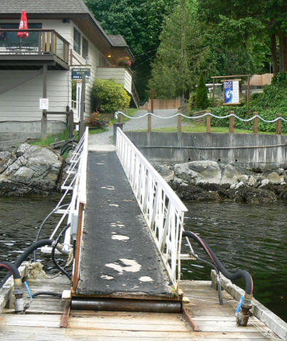
This is the only dock I managed to remember to get pictures at low and high tide. We stayed at Egmont Marina to preposition us for our trip into Chatterbox Falls. The current that runs past this dock is very strong all the time. It is just to the west of Skookumchuck Narrows. There is a counter current that runs close to the docks. When docking it is extremely important to know which way the current –at the docks – is running. There were five large yachts tied up to two sections of the dock. After dinner there was some action going on out on the docks. We stepped out to see if there was a problem, and yes – there was a BIG problem! The current and the winds were working in conjunction with each other and so all five boats had been tugging and pulling the dock away from the main dock! There was one shackle, on the inboard side of the dock, holding the two sections of docks together, as the shackle on the outboard side of the dock had given way when the pin worked free. First thing they did was move the most after boat onto a safe dock. That relieved a lot of pressure on the two sections with the now four boats. Meanwhile a line had been tied around the two sections in hopes of keeping the two docks from separating any worse and to keep the final shackle from taking all the strain. By now the current is changing and the dock is naturally wanting to go back together, but now there is no shackle for the outboard side of the dock. No shackle?? That can’t be – hold on – DESERT VENTURE seemed to have a “spare”, just the right size, shackle on board. That same shackle is now holding Egmont Marina’s dock together. One other note, Captain made sure the pin was seized properly and there will be no wondering how long that shackle will last – it will last till they don’t want it any longer.
I have so much to tell you about our last couple weeks, but it will have to wait for another time. And, we are moving further north in the next week, so that means even more new tales from DESERT VENTURE. And so, we keep going – and why is that ?? Because we can!

I am Uliana Malaspina of the Noble Malaspina Family Dynasty and would like to know if you could follow the course taken by Marchese Alejandro Malaspina, the Explorer. I think it’s great how you travel and see.
Thank you for your great comments to my blog. I appreciate your enjoying our travels.
For US to make his voyages? While we have the capability to cross oceans, we do not have the desire. We have cruised from SE Alaska, down through the Inside Passage, out onto the Pacific Ocean as far south as Barra de Navidad, Mexico. So, in that sense we have been to much of the west coast of North America that your relative traveled. Though we do have the ability to go further north to the outside more easterly and northerly borders of Alaska, we would not wish to attempt that part of his cruise, either. The weather is quite animated and very hard to forecast, as it is so far to the north and has its own weather patterns, so to speak. There are pleasure boaters that will go out there. They are more of the explorer and advenuturous spirit of Explorer Malaspina than either my captain husband or I would like to experience. 🙂
One the very things that makes our cruising so alive and even more impressive to us, is that we can go with ease due to the exploration of George Vancouver, Malaspina, Cortez and so many more of their officers and crew, and many other explorers. Much of the area is all but as pristine as when they first traveled through. We have such marvelous tools to assist us in our travels. Wonderful engines, GPS, radar, detailed nautical charts, guides and navigational aids, that the early explorer could never have dreamed possible. For their first efforts and all those that have come before us, we are truly grateful and relish in the wonders we explore when we cruise.
Best regards,
I would like to see all the places that my relative, Marchese Alessandro Malaspina, the Navigator, saw; especially in the Great Northwest. Nice work.
so beautiful and relaxing to see these photos