Day One
I posted a brief photo blog of Day One on April 24. (I took the photos with my cell phone, then created the blog with the WordPress App on my phone.) On many voyages I create the blog as we move along, posting it via our air card. The connectivity on this voyage was spotty and my timing was off for creating a blog my traditional way. And today, while working on this blog, I managed to post it TWO TIMES when I didn’t want it posted at all! I hate user technical error – especially when it is mine. 🙂 So, please delete those pre-edit missives and enjoy this version.
Our conditions were good the entire voyage. Not flat, but certainly manageable with little discomfort – if you were sitting. I managed to make meals and exercise at the same time. The exercise wasn’t deliberate – it is a side effect of staying balanced and upright while working in the galley. Honestly, it was a wake up call to my lazy winter sedentary ways. I feel myself getting stronger daily. Talk about enforced activity. 🙂
Voyaging on the west coast of the United States requires sophisticated ocean condition analysis. (You don’t have to plan. Many go with a schedule. And they are the ones that talk about huge seas, exciting and dangerous voyages. We prefer boring.) We are concerned with wind speed and swell height and period. It matters what direction the wind and swell come from, also. Sunshine, cloudy skies, fog, and rain aren’t deciding factors. They can contribute to the overall trip, but wind and swell make the trip a joy, pain, or a “no go”.
Pay attention to the sea state in my photos. The photos show you our conditions better than I can tell you. The points and capes are obstacles on the coast. Passing each one safely is a check off. Planning arrival at each of these critical areas is part of the planning. Mornings are generally the calmest time to round Point Conception. We like to be around before the afternoon winds pick up. This time was no different.
Point Conception
We’ve rounded Point Conception many times. And, in general, it is always good conditions. It isn’t luck. It is planning. You can see that the water is mildly animated. There is a mixed swell that is causing some ripples on the water. A NW swell is mixing it up with a SE swell. We experienced this until we got north of Point Arguello, our next “obstacle”.
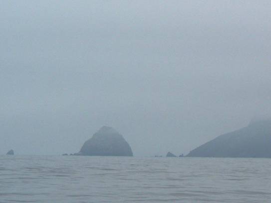
Point Arguello

It wasn’t a sunny day. Sun is not required for a good voyage.Nice, but not required. It was chilly and we ran the generator for much of the day. And now you can get a better look at the mixed swell that stirred up the surface water. Not to worry, around the point and continuing north, away from its effect, the ocean settled down.
Sunset
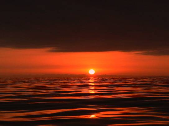
The sun finally showed itself, as it dropped below the clouds, and just before it set. Sunset on a glossy ocean is a nice way to go into darkness.
Going into dark mode is always a bit unsettling to me. Lights go out. We get our our flashlights. We cover unnecessary indicator lights with tape, to assist in our night vision. We settle in, adjusting to the dark, and planning our night watches.
We passed Point Sur in the night. I know, because I posted it in the log. Going up and down this coast is always a different story. Though the voyage route varies little, it’s never the same. We pass the same points, but time of day and conditions change. We sometimes are in fog for hours on end.
Day Two

This is the lighthouse at Pigeon Point. We passed it mid-morning on day two. We are still south of San Francisco Bay.
When we departed Santa Barbara we knew we could make it to San Francisco Bay. We planned to keep going, bypassing the bay, if the weather held. It became clear the next morning that we could continue on beyond the bay. [Apologies to all our SF Bay
friends.]
Pillar Point Harbor
We stopped in Pillar Point Harbor for fuel. We arrived around noontime. The photo below was taken at the fuel pier. We’ve been here enough that we recognize a boat or two.
Fueling
Fueling is one of my least favorite boating activities. I run the nozzle, while the Captain watches the tank tender (marine fuel gauges). We are very aggressive, and at the same time cautious, in our refueling. We both do our job to make sure we get our tanks full and never spill a drop. I spend most of the time on my knees, at the ready to start or stop the flow of fuel. I love anytime I can get out of fueling duty – which isn’t often. Our crew buddy, John, did the duty when we voyaged the Baja Peninsula. And on this voyage, JT did my fueling job. Nice!
Fuel docks are all different. Docks that cater to larger boats often have higher docks. On occasion I have had to crawl up onto the dock! Other times I can step on to the dock at the same level as the swim platform. The docks are built for the majority customer. I wish had enough photos to do a Fuel Blog. The problem is when we are fueling, it is all business. Not much time for photo ops. However, we refueled here at Pillar Point one other time, and the nozzle is so different I had to have a picture.
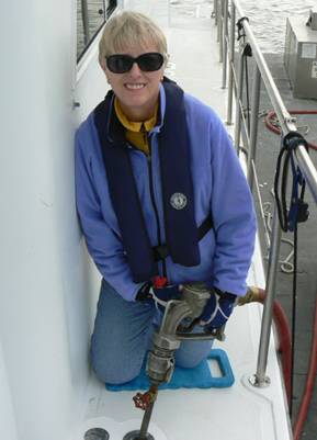
This is the biggest and most complicated nozzle I’ve worked with. Note the pipe coming out of the nozzle with the valve wheel. The hose has a large diameter, too. On some boats that pipe disappears down into the tank opening. The wheel adjusts the flow speed – something that is generally managed on the docks. I needed both hands to hold the huge main fuel nozzle. It was the on/off for the flow. No way was I willing to set the speed of the flow. (Is it righty tighty or ???) Captain did that. Speed of flow is a big deal. The bigger the tanks, the faster they want the fuel to flow. However, being a small boat we don’t want a gusher flow. If the fuel comes too fast, the fuel line may choke and spew fuel right back out the deck opening. A really bad thing. The laws regarding fuel spills are nothing to mess with. How about something that models a moderate water hose – a speed that gives me control. Anyway…that is the biggest fuel nozzle – and the most complicated one I worked. Thanks, JT, for doing fuel duty!
It took about an hour to fill three tanks – both aft saddle tanks and the day tank. Some of you are thinking it wouldn’t have taken so long if the fuel flowed faster. Not necessarily so – just think of all the paperwork time if the fuel got away from you. We err on the slow side of caution. We took on about 380 gallons. With a three cent discount, diesel fuel was $4.16 a gallon. Needless to say – though I will anyway – it costs considerably more to cruise now than it did a few years ago!
And on our way we went, destination Eureka, by sundown tomorrow (Friday).
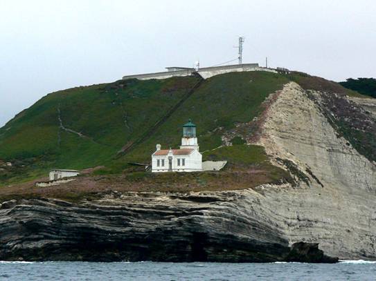
Point Reyes Light House
We’ve passed this light house many times. I think this is the first time I saw the light house. It has either been in the fog or the dark. I have seen the light. [Did I just say that?:-)]

Second Night
Next thing I know it is lights out time again. I don’t know where the day went! Into the darkness we went. My watch is the mid-watch – midnight to 0300. It has never been my favorite time. I have a hard time getting to sleep at 2100, knowing I have to get up in three hours. And just about the time I need to get up, I finally drop into a deep sleep, or even worse, I never sleep. So, this night I requested the 0300 watch. I figured I would get a decent six hour sleep and be more alert. I did get a better rest and showed up to relieve JT on time.
And he said, “Go back to bed. I’ll do your watch.”
No, no, JT, I can do it, really.
“No, I want to. I’m having fun!”
Really? You sure?
“Yes, I’m sure.”
I would hate to ruin your fun. Good night. Oh – and have fun. 🙂
Day Three
It was good to get up today, rested, and know that tonight we sit at a dock. Day cruising is good. All day long we cruise along, aware that our engines are moving us. We hear them, but they are just part of the experience. When the lights go out, and we’re running in the night, the engines seem louder to me. There are no visual distractions, no moving around the boat easily. I am more aware of the sounds of the engines. Don’t get me wrong. I DO want to hear the engines – and know they are doing what is ask – get us up the coast. But in the night, they seem much louder. [Dear Port and Starboard engines, this is not a complaint. Honest.]
Cape Mendocino
Cape Mendocino has been our nemesis for months on end. In fact, on day three every distance measurement was based on Cape Mendocino. Weather was checked often for current conditions. You have to know there was no stopping us when the weather cooperated and gave us a nice flat ride around the cape. It was unpredictably nice. Generally we do some rolling when we make that right turn. This time it was flat. We enjoyed a nice ride around the cape and to the approach of the Humboldt River Bar. You might think we arrived when we got to the river bar, but the town of Eureka and Woodley Island Marina – where we stay, was another ten miles up the river.
US Army Dredge – ESSAYONS

Not an unusual site to us, this US Army Corp of Engineers vessel was dredging the channel. We had plenty of room to pass to his starboard side. Ten miles to go. Woodley Island Marina, here we come. The bar was flat as we crossed. Perfect arrival timing at the Humboldt River Bar.
We wasted no time rinsing the salt off the decks, connecting shore power, setting the house to order, and going up the gangway to the restaurant for dinner. The building seemed to sway as we waited to be seated. Ahhh, you have to love the sea legs that came with you when you walked ashore. It was nice to sit and be waited on after three days and two nights underway on the boat.
We voyaged 491 nautical miles, with a brief fuel stop. We averaged 8.4 knots/nm. We completed half the distance of our voyage to the PNW. It feels really good to have those miles behind us.
We are waiting out a weather system. Most of the commercial fishing boats were in and waiting, too. Conditions moderated enough for the hungry commercial fishermen. Several of them departed here, headed around the cape and south for salmon fishing in the Monterey area. Several crab fishermen have gone out picking up traps or dropping them off. No way, would we go out in these conditions. They are a hardy bunch, to say the least.
We now see our weather window. Departure is set for Tuesday at daylight. Meanwhile, we plan to rest up, do some boat projects, and prepare for the final leg – of the Northbound Voyage in 2013.

Wow the Endless Voyage continues in the Adventureous life on Desert Venture ,Great life and Photos of the places pasd along the way , Living so far frome the Ocean now Its great to see you two still out there enjoying the life at sea and ports of pleasure . Thanks for the postings , Crabs lookd great and Yummmey, And the LightHouses are great beakons in the foggy mornings im sure .
All the Best Angie & Capt.Bruce . Im positive he still has Keen eyes for the Crab Traps ..No wories in that dept ..Cureous youre Navagation aids. Does the Capt still get out on stare
y nights and run his legendary star shoots and sun lines at noon .Or has the Computer age mellowed him a bit …Joke there Eh’ ..Best to all on the Desert Venture….Frank @ Bishop , Ca………out
hi angie & bruce glad thinks are going nice how for north are you going, we will be leaving friday harbor the 25th or the 26th for so east with me debbie our middle son our middle daughter and her 3 kids keep us posted on your progress
john&debbie
Aloha – I enjoyed the pictures of sunset, light house and marina. The one that brought back the most memories was refueling operations – big change from the 199 days!
Mahalo,
Randy
All the pictures were great but that sunset picture is spectacular!! Glad you traveled so safely and quickly! Enjoy a few days of rest! Prayers for safe travels and good health!
Nirvana is waiting and ready for the WA. coast trip. The navy website looks possible for tuesday and wednesday. Will wait for the other WX sites to be more current. We miss Bruce to have his evaluation. Will travel to Ilwaco on sun/mon if it loks good for ocean next week. Jim and Naty
Hi Jim and Naty! We are watching the same weather. Has changed a little over the day, but we think it will still be a good window. Hope to see you along the way.
looks fun!! all of it!!
XX nancy
Well, you are moving along smartly! In record time as a matter of fact. Best of luck as you continue north. We will be watching for new posts. Safe travels! What is the final destination by the way?
Hugs, Elise and Roger
Thanks Elise and Roger. You ask the most asked question. Where will we end up? Who knows? It’s a “process”. Where have I heard that? ;->
Glad to hear you guys are finally underway !
Heading to a winter in the Caribbean.
All the best,
Mike
Reading your blog and seeing the photos make my sea legs itch to be on the water again, if only for a short time to bring back all the memories of the cruising life. To get the feel once more of those twenty-one days at sea on the thirty-three foot boat, going to the Marquesas. That was a fun trip. I’ll happily stand your watches for a few nights ;o)
Gigi
Should have posted the night watch years ago! Keep this up and I’ll never do another mid-watch. Yes! 🙂